Cartology and cliché
A new historical world atlas claims to break away from a purely Eurocentric view of the world. It almost succeeds
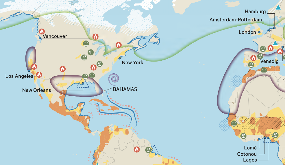

Section of the map with North and South America and part of Europe
Photo: C.H. Beck, München
Christian Grataloup's atlas aims to bring the history of the world - from the spread of Homo sapiens to the Arab Spring - closer to its readers in the form of maps.
The French author, professor emeritus of geographic history and widely known in Europe for his book “The Invention of Continents”, presents on almost 600 pages not only nearly 500 visually appealing maps, but also brief text introductions to relevant historic events.
In the recently published German edition of the book, the maps are interconnected and link to others dealing with similar topics. Thus, the chronologically arranged work can be read not only in chronological order, but thematically as well.
It is a work that you might want to pick up again and again to find out about spacial structures and geographical interrelationships over time.
The maps in the volume, which was first published in France, were largely taken from the journal “L'Histoire” and have been revised and visually standardised for this new publication.
Some of them deviate from the established perspective and - as in the case of a map on globalisation around 1900 - impressively showcase the supremacy of Europe and the USA.
“Grataloup presents world history in the classic style: spanning the entire world. In the end, however, it always returns to Europe”
This does not mean, however, that Europe does not continue to take centre stage in terms of graphics and content. Grataloup has not followed the familiar division of epochs into prehistory and early history, antiquity, the Middle Ages and modern times, which is often criticised as being Eurocentric, but he has arranged the book in 13 chapters, the main part of which, from chapter six onwards, deals with modern times.
In this way, he is able to present the history of the modern era with the attention to detail it deserves, but he does not escape the Eurocentric lens, as Europe becomes the central point of reference in the volume from 1500 onwards.
This is not only evident in the content structure of the work, but also in the individual maps: Europe is the point of reference for the “rest of the world”. All movements emanate from this continent and its development is described in particular detail.
Grataloup thus presents world history in the classic style: it spans the entire world and is refreshed by a dash of “Big History” - for example in the form of the colonisation of the earth by Homo sapiens in Chapter One.
“Particularly impressive, meanwhile, are other maps such as those tracing the effects of climate change”
This second emphasis is unfortunate as it is maps such as “The Domestication of Plants and Animals” and “The Black Death” or the visualisations of 18th century educated societies that broaden our perspective on the spatial interconnections of the world.
But, Grataloup also devotes a lot of space, sometimes too much, to modern wars and mostly well-known battles.
Meanwhile, other maps are especially impressive, such as those on “Climatic Changes”, which trace the local and regional effects of global warming.
From the destruction of resources to the increase in extreme weather events and the rise in sea level to zones of melted permafrost, they helpfully consolidate current scientific findings.
Other striking maps depict how the First World War became a world war through soldiers and resources from the colonies as well as associated powers, and how trains and rails linked Europe for the first time in the age of industrialisation.
The breadth of the rail networks shows the viewer how early an area was developed in terms of transport.
“The history of the world, global history, continues, but it is also more contradictory and complex than this atlas leads us to believe at many points”
Using the atlas's system of references, one can then compare these transport routes with those of the European merchants and traders in the 13th century or with those of the Hanseatic League. These opportunities for comparison are a great strength of the work.
At other points, however, the atlas falls short of its graphic potential, for example in the depiction of the sub-Saharan slave trade between the 7th and 19th centuries. It is true that it shows from where people were trafficked. However, the economic links between slavery and the colonial economy are not shown, for example how the work of the abductees on the sugar plantations in the Caribbean and on the cotton plantations in the USA boosted exports.
And in general, it would be helpful to see a more detailed examination of the African continent - also beyond the former French colonies. Following the foreword by historian Patrick Boucheron, who marks the atlas as unfinished with the remark “History continues”, it would be apt to conclude by paying tribute to it in this way: The history of the world, global history, continues, but it is also more contradictory and complex than this atlas leads us to believe at many points.
The volume is always at its strongest when it leaves the well-trodden paths of world history and visually explores theglobal interconnections outside of Europe. For this reason alone, it is worth reading.